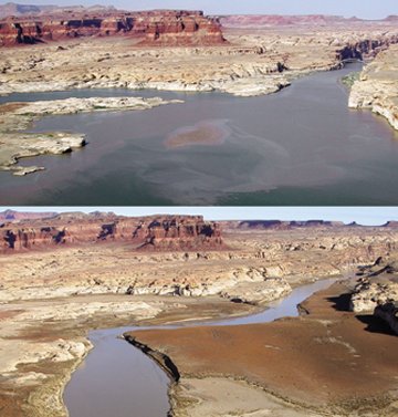
An ongoing drought that began in 2000 is driving down reservoir levels in the western United States. Utah’s Lake Powell fell more than 10 meters between June 2002 (top) and December 2003 (bottom)—a change unrelated to the different seasons depicted in the photos. Last week, the U.S. Geological Survey reported that the annual flow volume of the upper Colorado River from 2001 through 2003 averaged 6.66 cubic kilometers, barely half the average flow there during the Dust Bowl years, between 1930 and 1937. From analysis of tree rings, USGS scientists infer that the average flow rate of the upper Colorado River between 1590 and 1594—previously the worst drought in the past half millennium—was about 25 percent higher than that measured between 1999 and 2003.


