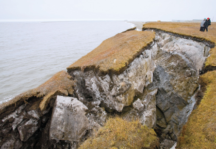
Gray waves surged over miles and miles of open water, breaking against the bluffs underlying Kaktovik. The tiny village sits precariously on the Beaufort Sea, a frigid body of water bordering Alaska’s northeastern Arctic coast. As the choppy waters inundated vulnerable stretches of shoreline, the surf carved deep chasms into the tall bluffs.
![](https://i0.wp.com/www.sciencenews.org/wp-content/uploads/2011/07/14593.jpg?resize=300%2C208&ssl=1)
![](https://i0.wp.com/www.sciencenews.org/wp-content/uploads/2011/07/14594.jpg?resize=300%2C202&ssl=1)
![](https://i0.wp.com/www.sciencenews.org/wp-content/uploads/2011/07/14595.gif?resize=272%2C300&ssl=1)
![](https://i0.wp.com/www.sciencenews.org/wp-content/uploads/2011/07/14596.jpg?resize=300%2C177&ssl=1)
![](https://i0.wp.com/www.sciencenews.org/wp-content/uploads/2011/07/14597.jpg?resize=245%2C300&ssl=1)
Torre Jorgenson, a geomorphologist working near Kaktovik, watched the storm boil up, shaking homes and boats for nearly two days in July 2008. Dramatic erosion followed soon after. Blocks of graphite-colored earth, as much as 10 meters wide and several meters deep, toppled into the sea one by one like skyscrapers in a Japanese monster film.
“The locals had never seen that type of erosion,” says Jorgenson, also president of the U.S. Permafrost Association. “It was something new, a regime change.”