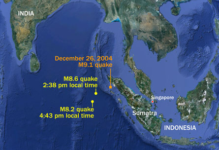
One of the most seismically shaky places on the planet got rattled again on April 11, when a magnitude 8.6 earthquake struck near the Indonesian island of Sumatra. A massive aftershock, magnitude 8.2, followed two hours later.

The quake’s epicenter was located about 400 kilometers off the island’s west coast, near — but not on — the boundary where the piece of Earth’s crust that underlies Sumatra and parts of southeast Asia rubs against the plate beneath Australia. Vibrations detected around the world suggest the quake occurred at a depth of about 22 kilometers, though this number may change after further analysis.
“We know that this was a big, shallow earthquake,” says Don Blakeman, a geophysicist with the U.S. Geological Survey’s National Earthquake Information Center in Golden, Colorado. “We know that it was felt in mainland India.”
Despite its size, Wednesday’s quake didn’t lift up the massive wall of water seen when a magnitude 9.1 earthquake struck Sumatra in 2004. A tsunami watch for the Indian Ocean issued on Wednesday proved unnecessary after the tremors pushed up only a small wave less than a foot high, says Blakeman.
That’s because the unnamed fault ruptured in a strike-slip fashion, similar to how the San Andreas Fault in California behaves. Rocks on either side of the fissure slid past each other mostly horizontally, with little vertical movement. The megathrust earthquake in 2004, in contrast, buckled the seafloor upward.
“If you don’t have vertical motion, you don’t have the process that lifts water upward,” Blakeman says.
Strike-slip quakes in this area aren’t unheard of. Three smaller ones occurred in 2006, 2007 and 2012. In the wake of this latest, especially large, strike-slip quake, smaller aftershocks close to magnitude 5.0 have continued to shake the area.


