Biologists have long known that large areas of roadless space are generally far more beneficial to the natural environment than multiple smaller areas broken up by roads. Roads lead to increased human activity, groundwater contamination, introduction of invasive species, and other environmental compromises. A new mathematical analysis, published in the May 4 Science, offers a visual model of the quantity and distribution of roadless areas in the United States, providing a clear and useful guide to the ecological value of land for scientists and policymakers.
“If you’re talking about your stock portfolio, you don’t just say ‘I have 768 shares of stock’ and stop,” says Raymond Watts, a geographer at the U.S. Geological Survey Science Center in Fort Collins, Colorado and lead researcher on the project. “You look at the value of the various shares of stock you have.” Similarly, Watts and his team of researchers wanted to know how much environmental “wealth” the United States has in open space, taking into account the high value of remote land.
Watts says that until now, scientists have had no good way of measuring the value of open space. The stumbling block was the apparent complexity of the task. It is very difficult to measure precisely how pristine and ecologically important a particular piece of land is, because this depends on a host of regional factors. For example, the type of terrain, rainfall patterns, and habitat all make a difference. Calculating such factors throughout the United States would be an unmanageable challenge.
Instead, Watts and his team have come up with a mathematical technique based on a simple observation: “Generally speaking, you have an invulnerability to those conditions that increases as you leave the road behind,” Watts says. “The simplest way to express that is to make it linear with distance.” He acknowledges that focusing only on distance greatly simplifies the reality but argues that having a clear indicator of the value of open space can help policymakers assess the impacts of various land use decisions.
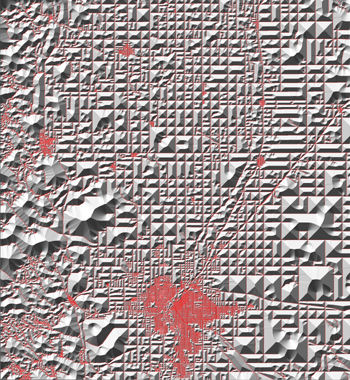
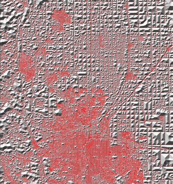
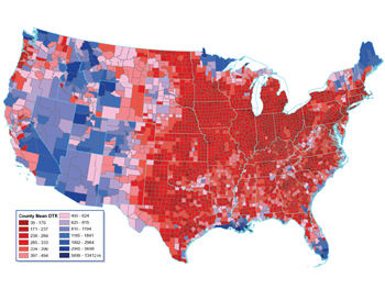
Watts and his team have created a three-dimensional map to show open space and its value at a glance. They started with a flat map of the contiguous United States divided into very small squares, with each square representing a 100-foot-by-100-foot parcel of land. The researchers covered each square with a column whose height is based on the area’s distance from the nearest road. (Squares that contain a road have a column height of zero.)
Within a given “roadless” region of open space, the highest column ends up being at the center of the region. The columns get shorter as they get closer to a road. The result is that each region of open space is covered by a sort of pyramid, or mountain, with the highest point being the furthest from the surrounding roads. The researchers call these mounds the “roadless volume,” and they use the height levels to estimate the ecological value of a section of land.
In the contiguous United States, the point that’s furthest from any road is in coastal Louisiana, where swamps deter the construction of any type of road, even narrow dirt roads. The most remote landlocked spot is in the southeastern corner of Yellowstone National Park, 20 miles from the nearest road. “That shocks a lot of people,” Watts says. “If they don’t know the western part of the U.S. very well, they imagine that there are these vast areas where you can ride your horse for days.”
The new map could help lawmakers assess the impacts of proposed roads, Watts says. Dead-end roads that head into the heart of open space have a far bigger impact on roadless volume, for example, than roads that are near other roads. Watts imagines that roadless volume could be a useful resource management tool. For example, during his Presidency, George H.W. Bush mandated no net loss of wetlands, and similarly, a future U.S. President might want to aim for no net loss of roadless volume.
Watts also hopes the map will be used in planning residential and commercial developments. Currently, he says, planners tend to calculate the distance from urban centers when considering the impact of urban sprawl. Watts argues that it may be more important to consider the intrusion into pristine areas.
“The road network is the lifeblood of our society,” Watts says. “There are huge benefits to roads, but at some point, we need to learn how to balance those benefits with the ecological [benefits that] roadless areas provide.”
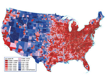
Watts and his team used the same data to create the following two maps, which depict amounts of open space per county and per person.
If you would like to comment on this article, please see the blog version.